
Digital Forestry Platform for GIS, Remote Sensing & Reporting
Upload field data, generate GIS maps, and build forestry reports online. Powered by Green Forest Conservation Pvt. Ltd.
Upload
Field data, boundary shapefile, or Excel/CSV
Analyze
GIS, remote sensing & statistical analysis
Map
29+ map types, auto-generated
Report
Download-ready technical reports
Forestry Tools
Upload your field data and run any of these tools directly on the platform — GIS mapping, remote sensing, forest inventory, environmental studies, and more, from raw data to a finished report.
Forest Inventory and Survey
9 services availableWe provide forest inventory and field survey services for collecting reliable information about forest resources.
- Forest inventory and mensuration
- Tree measurement and field data collection
- Species and diameter-class analysis
- Growing stock and harvestable stock estimation
- Forest condition assessment
- Resource inventory
- Biodiversity observation
- Data processing and analysis
- Inventory-based reporting
GIS Mapping and Spatial Analysis
10 services availableGFC provides GIS-based mapping and spatial analysis for forest management and planning.
- Forest boundary maps
- Compartment and block maps
- Forest resource maps
- Survey and sampling maps
- Slope and elevation maps
- Land-use and land-cover maps
- Road and drainage maps
- Satellite-based forest maps
- Operational plan maps
- Publication-ready forestry maps
Remote Sensing and Satellite Analysis
9 services availableWe use satellite data and remote sensing techniques to understand forest conditions and changes over time.
- NDVI analysis
- EVI and NDWI analysis
- Forest change detection
- Land-cover classification
- Vegetation condition assessment
- Satellite-based forest monitoring
- Forest disturbance analysis
- Fire and burn-area analysis
- Carbon and biomass mapping
Forest Management and Operational Planning
12 services availableGFC provides technical support for sustainable forest management using inventory data, GIS, and statistical analysis.
- Forest Resource Assessment
- Forest Structure and Condition Analysis
- Normal Forest Assessment
- Growing Stock Estimation
- Harvestable Stock Assessment
- Sustainable Yield Estimation
- Forest Inventory Analysis
- Forest Management Planning
- Operational Plan Preparation
- Block and Compartment Planning
- Forest Management and Yield Analysis
- Technical Management Recommendations
Carbon, Biomass and Forest Change Analysis
8 services availableForest resources are changing continuously. Reliable spatial and field information is important for understanding these changes.
- Forest carbon assessment
- Carbon stock mapping
- Biomass estimation and mapping
- Vegetation analysis
- NDVI-based change detection
- Land-cover classification
- Forest change assessment
- Spatial analysis of forest resources
Forest Fire Monitoring
7 services availableGFC provides satellite-based forest fire monitoring and fire-related spatial analysis.
- Forest fire detection
- Fire incident mapping
- Historical fire mapping
- Fire occurrence analysis
- Burn-area mapping
- Burn severity analysis
- Forest fire monitoring support
Soil Analysis and Assessment
14 services availableGFC provides soil sampling, laboratory analysis, and spatial soil-nutrient assessment to support forest and land management decisions.
- Soil Sample Analysis
- Soil Depth Assessment
- Soil pH Analysis
- Soil Carbon Analysis
- Soil Nitrogen Analysis
- Soil Phosphorus Analysis
- Soil Nutrient Assessment
- Soil Analysis by Slope
- Soil Analysis by Elevation
- Soil Analysis by Aspect
- Soil Analysis by Land Cover
- Soil Nutrient and Topography Comparison
- Soil Spatial Distribution Mapping
- Soil Quality Assessment
Environmental Studies
14 services availableGFC provides technical support for environmental and natural-resource-related studies, combining field data with spatial analysis.
- Environmental Impact Assessment (EIA)
- Initial Environmental Examination (IEE)
- Brief Environmental Study (BES)
- Environmental Baseline Survey
- Environmental Impact Assessment Report
- Environmental Monitoring
- Biodiversity Assessment
- Flora and Fauna Survey
- Ecological Assessment
- Natural Resource Assessment
- Forest and Vegetation Assessment
- Land Use and Land Cover Assessment
- Environmental GIS Mapping
- Environmental Data Analysis and Reporting
Non-Timber Forest Products (NTFP) Assessment
12 services availableGFC provides technical support for non-timber forest product survey, assessment, and sustainable management planning.
- NTFP Inventory
- NTFP Species Identification
- NTFP Resource Assessment
- NTFP Availability Assessment
- NTFP Distribution Mapping
- NTFP Density and Frequency Analysis
- NTFP Abundance Assessment
- NTFP Regeneration Assessment
- NTFP Harvestable Quantity Estimation
- NTFP Sustainable Harvest Assessment
- NTFP Market and Value Analysis
- NTFP Management and Utilization Plan
Thinning and Improvement Felling Plan
8 services availableGFC generates grid-based thinning and improvement felling plans with real diameter-class and residual-stand analysis.
- Grid-Based Thinning Tree Selection
- Improvement Felling Selection
- Diameter Class Breakdown
- Residual Stand Analysis by Diameter Class
- Residual Stand Analysis by Species
- Tree Condition Assessment
- Felling Tree Marking Guidance
- Ghatgaddi/Katan Register Support
Tree-Marking Volume Valuation
8 services availableGFC computes marked-tree stem, branch, and net timber volume using real DFRS-style equations, output in government schedule format.
- Tree Stem Volume Calculation
- Branch Volume Calculation
- Top-Diameter (10cm) Ratio Adjustment
- Net/Gross Volume by Grade Class
- Fuelwood (firewood billets) Estimation
- DBH-Class Distribution Summary
- Species-wise Volume Rollup
- Government Schedule Report (Schedule 2/3/4)
How GFC Works
Field Data Collection
Forest information is collected through field surveys, inventory, measurements, GPS, and other appropriate methods.
Data Processing
Collected information is checked, organized, and prepared for analysis.
GIS and Remote Sensing Analysis
Spatial data, satellite imagery, terrain information, and forest inventory data are analyzed according to the requirements of the project.
Forest Analysis
Forest condition, growing stock, harvestable stock, sustainable yield, carbon, biomass, change, or other required parameters are analyzed.
Maps and Reports
The results are presented through maps, tables, charts, technical reports, and operational planning documents.
Management Support
The final information can be used by forest managers, community forest groups, consultants, researchers, and concerned organizations for planning and decision-making.
See a Real Example
An actual map generated by GFC — for a sample (non-real) boundary.
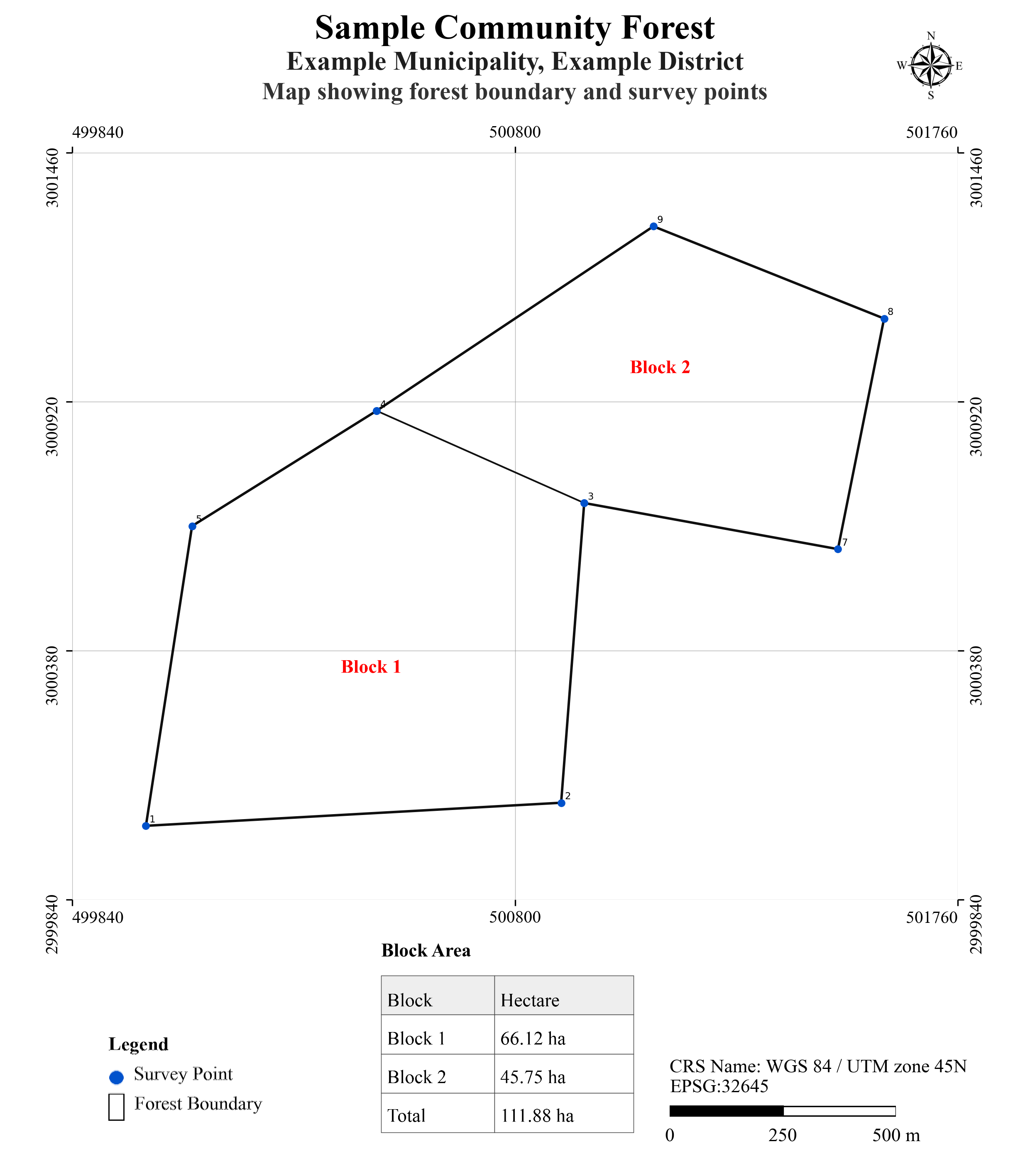
Boundary map with block-wise area table, survey points, and legend — one of 29+ map types available.
Our Key Areas
Forest Conservation
Supporting practical forest conservation and monitoring activities.
Scientific Forest Management
Using forest inventory, spatial information, and analysis to support sustainable forest management.
GIS and Remote Sensing
Providing spatial analysis and satellite-based information for forestry applications.
Forest Research
Supporting forestry research, field studies, data analysis, and technical documentation.
Environmental Studies
Providing technical support for environmental and natural resource-related studies.
Digital Forestry
Developing practical software and online tools for forestry data, analysis, mapping, and reporting.
We aim to make forestry information and digital tools more accessible for practical use in Nepal.
Who We Work With
GFC services and digital tools can be useful for:
Our Vision
To contribute to better forest conservation and sustainable forest management in Nepal through scientific knowledge, reliable data, modern technology, and practical forestry solutions.
Our Mission
To provide reliable forestry services and digital solutions that connect field-based forest information with GIS, remote sensing, scientific analysis, and practical forest management.
Share Your Feedback
Rate your experience with GFC — no account needed.
 GFC Assistant